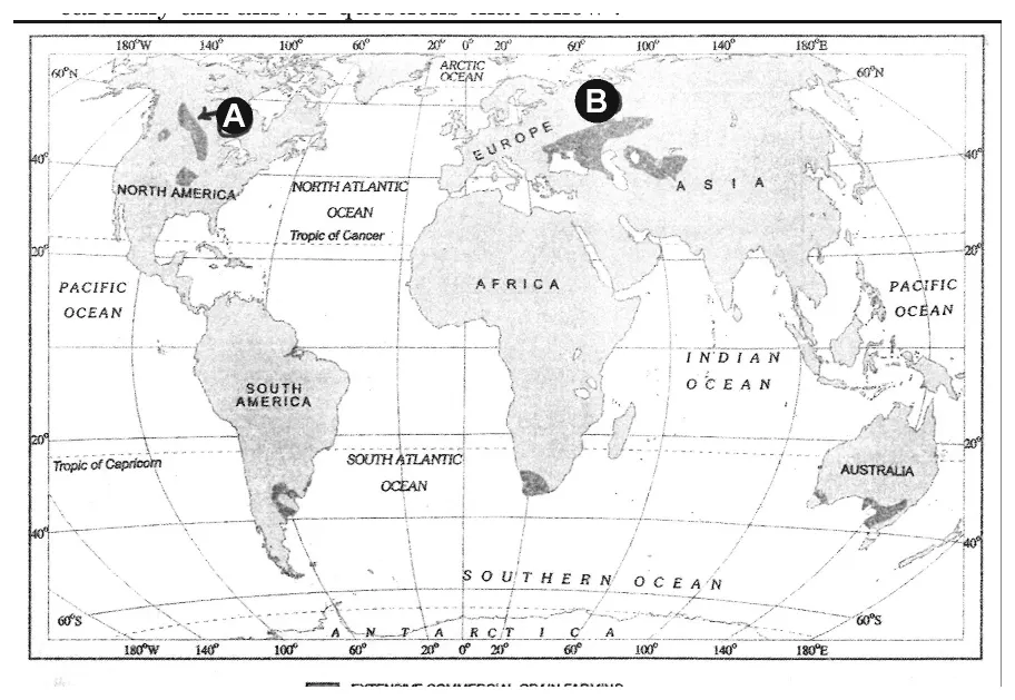
Write the geographical name of the area marked as A.
Write the geographical name of the area marked as A.
Official answer
The area marked A is the Eurasian Steppes — the temperate grassland belt stretching from Ukraine and southern Russia across to Kazakhstan.
This region is one of the five classic world zones of extensive commercial grain farming covered in the NCERT chapter on Primary Activities.
Marking scheme
- 1.1 mark for correctly naming the region as the Eurasian Steppes (or an equivalent description: Russian/Ukrainian/Kazakh steppes).
Hint
Identify the temperate grassland belt located in Eastern Europe–Central Asia on the extensive commercial grain farming map.
Quick oral answer
Area A is the Eurasian Steppes, the grassland belt from Ukraine through southern Russia to Kazakhstan, known for extensive mechanised wheat farming.
Common mistakes
- 1.Confusing the Eurasian Steppes with the Prairies of North America on the world map.
- 2.Writing only 'Russia' instead of the fuller regional name 'Eurasian Steppes'.
- 3.Not recognising the characteristic mid-latitude grassland location of the region.
Analysis and explanation
This is a map-based identification question from the topic of extensive commercial grain farming.
Concept
- Extensive commercial grain farming is practised on large, mechanised farms in the mid-latitude grasslands of the world, mainly to produce wheat for export.
- The five classic regions shown on the world map are the Eurasian Steppes, Prairies of North America, Pampas of Argentina, Velds of South Africa, and Downs of Australia.
Application to the map
- Area A, located across the temperate grassland belt of Eastern Europe and Central Asia, corresponds to the Eurasian Steppes.
Exam tip: Learn the exact location, spelling and extent of all five extensive-grain-farming regions on the world map — CBSE frequently sets map-identification questions from this chapter.
Note: Region identification follows the standard NCERT map convention for this topic; always confirm against the exact printed map in the question paper.
Interesting facts
The Eurasian Steppes stretch over 8,000 km from Hungary in the west to Manchuria in the east, one of the largest grassland belts on Earth.
Ukraine, part of the Eurasian Steppe belt, is historically called the 'breadbasket of Europe' due to its fertile chernozem (black soil).
Wheat farming in the Steppes is heavily mechanised, with very few workers managing thousands of hectares using combine harvesters.
Question details
Q18 of 36 questions
- Board
- CBSE
- Class
- Class 12
- Subject
- Geography
- Year
- 2026
- Section
- Section B
- Marks
- 1
- Chapter
- Primary Activities
- Topic
- Extensive Commercial Grain Farming — World Regions
- Bloom's level
- remember
- Syllabus topic
- Part A Unit 4: Fundamentals of Human Geography — Primary Activities: Extensive Commercial Grain Farming
- Author
- CBSE
- Reviewed by
- Padhantu Academic Team
Spotted a mistake or something unclear?
Tell us and we will fix it.
Frequently asked questions
Which five regions are shown on the world map of extensive commercial grain farming?
The Eurasian Steppes, Prairies of North America, Pampas of Argentina, Velds of South Africa, and Downs of Australia.
Why is the Eurasian Steppes suited to extensive grain farming?
Its vast, flat, fertile chernozem grasslands, continental climate and low population density allow very large mechanised wheat farms with minimal labour input.